Олимпиада читать далее
Галерея цитат
Знаете ли, какой самый верный способ сделать вашего ребенка несчастным, - это приучить его не встречать ни в чем отказа.
Жан-Жак Руссо
Новости факультетов
Пожароопасный сезон в лесах СКО в самом разгаре. Правила обращения с огнем и любовь к природе – первоосновы воспитания наших маленьких сограждан. В ра читать далее
17 апреля 2026 года в рамках Недели науки состоялась ролевая игра «Суд по уголовному делу». Мероприятие прошло как открытый уголовный процесс, участни читать далее
17 апреля 2026 года в стенах Kozybaev University состоялась торжественная церемония вручения именных стипендий, посвящённых наследию Александр Сергеев читать далее
16 апреля 2026 года на факультете истории, экономики и права, в рамках декады науки состоялась торжественная церемония оснащения сертифицированного це читать далее
10 апреля 2026г на факультете истории, экономики и права прошла Секция 7-«Правовые и социально-экономические аспекты развития общества в условиях глоб читать далее
Гранты читать далее
В Северо-Казахстанском университете им. М. Козыбаева состоялась Международная научно-практическая конференция «Козыбаевские чтения – 2026», посвящённа читать далее
8 апреля 2026 года образовательные программы, разработанные Академией Международного финансового центра «Астана», были официально переданы в СКУ им. М читать далее
7 апреля 2026 года медицинский факультет НАО «Северо-Казахстанский университет им.М. Козыбаева» в рамках празднования Международного дня здоровья о читать далее
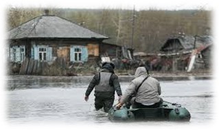
Моделирование развития паводковой ситуации в Северо-Казахстанской области с построением полномасштабной модели на основе данных дистанционного зондирования Земли
Приоритетное направление: Информационные, телекоммуникационные и космические технологии, научные исследования в области естественных наук
Руководитель проекта: Сартин С.А., к.ф.-м.н.
Исполнители проекта: Рудер В.П., магистр, Щукина В.Н., магистр, Фомин И.А., магистр, Пономаренко А. С., магистр.
Сроки исполнения: 2018-2020 гг.
Объем финансирования: 94 200 000 тенге.
Цель проекта: Получение данных ДЗЗ (посредством аэрофотосъемки) с высоким пространственным разрешением и обработка их с помощью геоинформационных систем (ГИС). Разработка и апробация датчика для автоматического определения толщины снежного покрова.
Ожидаемые результаты: Разработать математическую модель прогноза весеннего половодья на реке Есиль, которая будет обеспечивать прогноз уровня подъема воды вблизи населенных пунктов с точностью 1-2 метра, позволит моделировать зоны вероятного затопления, отслеживать динамику процессов подтопления пойменных территорий, оценивать затопленные площади посредством БПЛА. Реализация данного проекта позволит получить и постоянно уточнять 3d модель пойменного рельефа.
Описание проекта: В настоящее время активно ведутся работы в области ДЗЗ с применением современного геодезического оборудования, а так же беспилотного летательного аппарата (БПЛА). Планируется, используя топографическую съёмку поймы реки Есиль (Ишим), данных о глубине снежного покрова в бассейне реки Есиль (Ишим) и профилей дна, полученных с помощью шестилучевого эхолота, создать полномасштабную модель разлива реки Есиль (Ишим) близ населённых пунктов и степени их подтопления. Разработка модели развития паводковой ситуации на промежутке между городами Сергеевка и Петропавловск. В модели будет предусмотрена оперативная корректировка с учётом вновь поступающих данных о состоянии снежного покрова в бассейне реки Есиль (Ишим).
Задачи проекта:
−получение высокоточных геодезических данных о пойме реки Есиль;
−получение данных о состоянии русла реки Есиль;
−разработка и реализация методов дистанционного получения данных о состоянии снежного покрова в бассейне реки Есиль;
−создание модели прохождения талых вод по руслу реки Есиль;
−визуализация данных и создание компьютерной модели для отображения развития паводковой ситуации.
−получение компьютерной модели показывающей зоны подтопления.